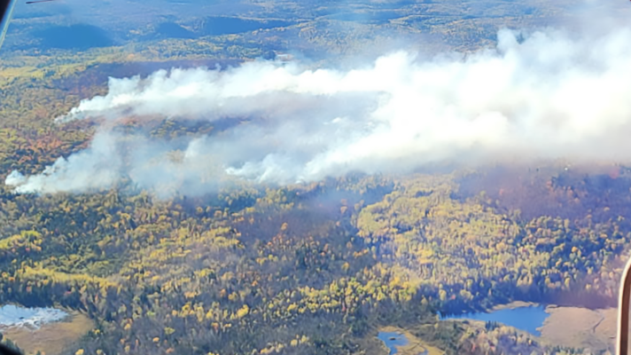
Firefighters made significant inroads with containment efforts of the large wildfires burning in St. Louis County, allowing authorities to downgrade some evacuation zones and reopen Town Line Road.
Drier, gustier winds in the forecast, however, mean community protection remains a top priority for authorities. The three wildfires have burned more than 30,000 acres of land in St. Louis County and destroyed more than 150 structures.
A community meeting to provide updates on the Jenkins Creek and Camp House fires is set for 6 p.m. Monday, May 19, at the Mesabi East School District high school auditorium, 601 N. First St. W., Aurora. The meeting will be livestreamed on the Eastern Area Complex Incident Management Team YouTube channel.
Northeastern Minnesota and a swath of central Minnesota remain under a "no open burning" restriction by the Minnesota Department of Natural Resources, and fire danger is listed as "Very High" in the wildfire area.

Camp House Fire
The 12,277-acre Camp House Fire is now 40% contained as of Monday morning. An update reported crews were able to connect the containment lines on the south side of the blaze around Brimson Lake, and on the north side, work continues to build protection around structures and key infrastructure. Equipment is being used to clear downed trees from areas near roads and within the fire perimeter.
Jenkins Creek Fire
The progress at Camp House, coupled with more crews arriving Monday, means personnel can move to active areas of the nearby 16,332-acre Jenkins Creek Fire. Progress was made there, too, but containment sits at 6% as of Monday morning.
Hotshot crews are working the perimeter and interior of the fire and will be supported by helicopters and drones to detect flare-ups that might occur Monday with the winds. The National Weather Service in Duluth reported it will be sunny with a high of 49 degrees, with winds picking up out of the east and blowing a steady 6-15 mph and gusts up to 33 mph. Humidity is expected to drop as low as 26%.

With the reopening of Town Line Road, the St. Louis County Sheriff's Office notes vehicles should avoid stopping anywhere in the evacuation “Go” zones to minimize exposure and risk. Drivers are also asked to take extra care when driving through due to the continued presence of emergency crews, utility crews and other curious or distracted drivers.
Portions of the Laurentian Ranger District in the Superior National Forest remain closed. An emergency forest order prohibits visitor entry to some camp sites and recreational areas. The closure may be modified or extended as conditions allow.
Munger Shaw Fire
The 1,259-acre Munger Shaw Fire near Cotton is now considered 95% contained. Management of that fire will transition back to the Cloquet area Minnesota Department of Natural Resources, which will continue monitoring the fire area.
While it is largely contained, hotspots within the interior may continue to smolder and produce smoke until there is enough rain.
Drones used to map the fire produced a more accurate size, decreasing it to 1,259 acres.
Road closures and evacuations have been rescinded by the sheriff in this area. The team is closely coordinating with St. Louis County on updating the evacuation status.
Emergency, disaster declaration
On Monday, St. Louis County announced in a news release that County Board Chair Annie Harala signed a Declaration of State of Local Emergency and State of Local Disaster. The declaration comes eight days after the Camp House fire began, and one week after the Jenkins Creek and Munger Shaw fires began burning.
The declaration is a procedural step as part of the state's process for counties to request state public disaster assistance for wildfire response and recovery activities.
The declaration by the Board Chair is valid for up to three days until the County Board can gather and vote on a declaration. The Board will have an emergency meeting at 9 a.m. Tuesday in the County Board room at the St. Louis County Courthouse in Duluth. As part of the emergency meeting, Sheriff Gordon Ramsay will update commissioners on wildfire activities and response.
The St. Louis County Sheriff's Emergency Management division is working with affected municipalities to conduct a damage and impact assessment report for submission to Minnesota Homeland Security and Emergency Management to determine eligibility for state public disaster assistance.
-
The agency states the new process will more closely align with U.S. Customs and Border Patrol measures for entering the U.S. in remote areas.
-
All three schools’ high kick routines qualified for state, while Brainerd and Crosby-Ironton also advanced with their jazz performances.
-
The two Northern Minnesota schools are among the 16 advancing from section competitions.
-
The legislation would withhold federal election funds from Minnesota until Secretary of State Steve Simon turns over voter data requested by the Department of Justice — a request Simon says is illegal.
-
The Department of Human Services plans to "revalidate" 5,800 providers of Medicaid services deemed high risk for fraud, waste and abuse.
-
The Minnesota Bureau of Criminal Apprehension is conducting an independent investigation of the in-custody death.
-
And: Judge denies injunction to pause Operation Metro Surge; MN Congressional Republicans introduce MN Voter Integrity Act; and Sen. Tina Smith endorses Peggy Flanagan.
-
The retiring senator's endorsement in the race between Flanagan and U.S. Rep. Angie Craig comes just before party members share their thoughts on Caucus Night, Feb. 3, 2026.
-
The State Fire Marshal is investigating the cause of the explosion in a six-unit building near the Duluth Airport.
-
Douglas and Tiffany Stewart died Jan. 30, 2026, after a train struck their vehicle west of Cass Lake in rural Hubbard County. The incident is under investigation.


