


WADENA — Conditions in the Redeye River Watershed have remained stable in the last decade, but a draft report shows some areas are facing emerging risks for nutrient levels and E. coli.
The Minnesota Pollution Control Agency released the Watershed and Restoration and Protection Strategy report, which provides updates from data last reported in 2016. Key findings and recommendations will guide local planning and implementation.
A public comment period is open until Wednesday, Dec. 17, and stakeholders are encouraged to review the report and submit feedback.
The Redeye River Watershed covers 899 square miles and lies on the west-central edge of the Upper Mississippi River Basin in central Minnesota. It encompasses parts of Becker, Otter Tail, Todd and Wadena counties, and includes the city of Wadena. The Redeye River begins at Wolf Lake, flows south to join the Leaf River, and eventually meets the Crow Wing River north of Staples.

All re-sampled lakes have water quality that supports aquatic recreation. However, East Leaf Lake shows too many nutrients in the water, indicating a need for proactive strategies to protect water quality, according to a news release.


Most streams in the watershed show good conditions for aquatic life. Three streams previously included on a list of impaired waters have been “delisted.” That means they have improved water quality. E. coli impairments persist in eight stream reaches, although two are trending in the right direction, the MPCA reported.
This updated report includes new data on climate trends, flow changes, and land-use impacts. It also outlines practical strategies to protect healthy waters and restore those at risk. These include practices such as septic system compliance, lakeshore buffers, and stormwater management, as well as watershed-wide practices, such as cropland nutrient reductions, increasing forested acreage and conservation easements.
The watershed contains about 633 total miles of river, of which 316 miles are considered perennial. Major rivers within the watershed include the Redeye, Leaf and Wing. There are also 11 creeks, seven county ditches, and numerous smaller flowages.
The watershed contains approximately 126 lakes covering 8,228 acres. The area is home to 73 lakes larger than 10 acres, including notable ones such as Wolf Lake, Gourd Lake, and the West, Middle and East Leaf Lake chain.
-
 Contributed/Nicole Neri|Minnesota ReformerProsecutors say the 20 TB of data in their possession includes surveillance footage from drones, body-worn cameras and cameras on federal property.
 -
 Contributed/National Weather ServiceThe National Weather Service confirmed the Murphy Lake Tornado on July 2, 2026, based on drone imagery and local resident reports of damage.
 -
 Erin Bowman/KAXEThe Strictly Mushrooms vendor market is open 10 a.m.-3 p.m. every Sunday in Pine River. The market has various goods, different classes and games for kids.
 -
 Lorie ShaullNew social media and domestic violence laws took effect Wednesday, July 1, 2026.
 -
 Canva illustrationThe Minnesota State Patrol reports the fatal crash on June 30, 2026, occurred when a motorcyclist struck the rear end of a northbound pickup truck on Highway 371.
 -
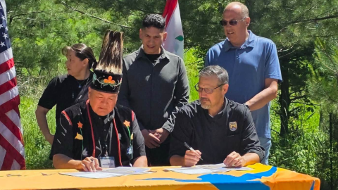 Contributed/Michael Fairbanks Facebook PageThe agreement provides funding for activities and programs, with three main areas where White Earth will take over responsibility — water and wild rice management, forestry and visitor services.
 -
 Contributed/Calandra Allen / Beltrami CountyIn Northern Minnesota — home to all six Minnesota Chippewa Tribe bands and the sovereign Red Lake Nation — a lack of mental health services has led to jails and emergency rooms filling the gap for years.
 -
 Plus: Bemidji is the clay target state champion; and check out KAXE's fireworks guide, The 4th Up North.
 -
 Megan Buffington/KAXEThe second round of severe thunderstorms on June 29, 2026, knocked out power for even more people than the first round did, with strong winds, large hail and heavy rain.
 -
 The National Weather Service in Duluth issued an upgraded alert of a "destructive" thunderstorm June 29, 2026, but the storm passed through much calmer than expected.


