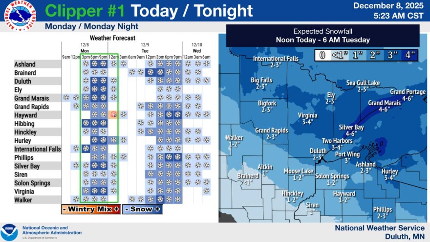
DULUTH — Most of the Northland will be getting snow between Monday and Wednesday, Dec. 8 through 10, but who gets how much could vary drastically just tens of miles apart.
The National Weather Service predicted two snow systems will deliver a one-two punch to the region over the next few days.
The first brings light snow starting Monday afternoon, with moderate snowfall in the evening tapering off early Tuesday. Most of Northern Minnesota will get 1 to 3 inches, but the Arrowhead north of Grand Rapids and Two Harbors may see 3 to 6 inches.

The weather service office in Duluth said the second storm midday Tuesday through Wednesday morning is “not your ordinary clipper.”
“Only, I would say, about 5% of clipper systems have this kind of moisture in it, and that’s what gives it the potential to deliver a really heavy band of snow for somebody,” said Ketzel Levens, a meteorologist in the Duluth office.
As of Monday morning, all of Northern Minnesota is predicted to get more than 2 inches of snow. But there will be a narrow band of snow that drops 6 to 8 inches on about a 50-mile stretch in northeastern Minnesota.

“But then not too long of a distance away from that, say maybe 20, 50 miles, somebody might only get like 2 inches because of the nature of this system,” Levens said. “It’s just still a little bit of a question mark on exactly where that’s going to be.”
Some models show that band over the Iron Range into the Twin Ports, and some show it moving south of Highway 2. Levens said with each forecast the National Weather Service puts out, the specifics will get a little clearer.
The “sharp snowfall gradient” that comes with that narrow band of snow could also drastically change travel conditions depending on location.
The Monday morning forecast from the National Weather Service in Grand Forks predicted in the second system, snow could fall as fast as an inch an hour north of Park Rapids and Ada, with a 60% chance of over 4 inches total.
Much of the Northland will also see blowing snow Tuesday into Wednesday, with gusts of 20 to 30 mph possible.
Clippers also bring cool air and stronger winds. There’s a good chance of dangerously low wind chills down to 30 below or colder for northwestern Minnesota later this week. Northeastern Minnesota will see more of a gradual cooldown, with temps going back to the single digits of late.
Levens reminded Minnesotans to keep an eye on the forecast as the impacts of the clippers become clearer.
“It’s going to snow somewhere at some point,” she said. “Pretty much everybody’s going to get at least a couple inches today and tomorrow, and somebody’s going to get more than that.”
Check road conditions before you travel, and have an emergency kit and shovel in your car.
“Slow it down, make sure your headlights are on and give folks extra following space, so you can get home safe and they can get home safe and our first responders can have a little bit less of a workload,” Levens said.
- March 'Spin That Ish' features Tedeschi Trucks Band, Charlotte Cornfield
- Bright Spot: Camp Christopher provides respite for grief
- Events Up North April 13-19: Book sales, Iron Range Earth Fest
- Superior National Forest plans 18 prescribed burns this spring
- Central Lakes College President Charlier to leave school after 10 years


