


DULUTH — A fast-moving spring snowstorm dropped roughly 4-10 inches of wet, heavy snow on much of Northern Minnesota overnight Thursday into Friday, March 12-13.
The North Shore was the hardest hit, with around a foot dropping on Hovland and Grand Marais and around 10 inches in Silver Bay, Duluth and parts of Carlton County.
The Borderlands saw closer to 4-6 inches of snow, though gusty winds up to 60 miles per hour created blizzard conditions for parts of northwestern Minnesota.
Many area school districts either delayed or cancelled school Friday. Snow is expected to continue Friday morning, with gusty winds lingering into the afternoon.
“It [the storm] did move fast, but it hit hard,” said Krystal Lynum, meteorologist for the National Weather Service in Duluth. “This was a pretty strong system in the fact that it moved through here so quickly but left these kinds of amounts around. ... Nothing completely historic, but it’s not something you see often either.”
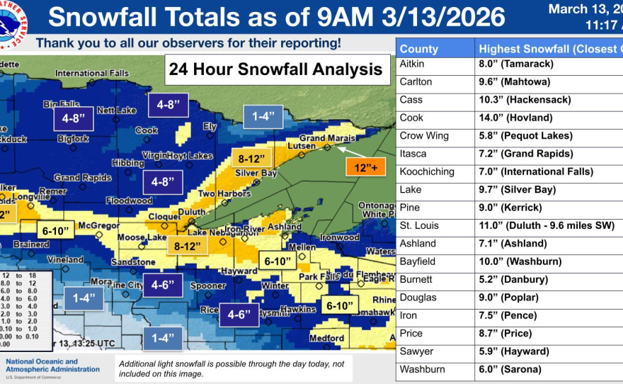

A trained spotter northwest of Hackensack reported 10.3 inches of snow Friday morning. Other reported totals include 7.5 inches near Park Rapids; 7.4 inches in Chisholm; 7.2 inches in McGregor and Grand Rapids, 7 inches in Cook, Embarrass and Tower; 6.5 inches in Hibbing; 6 inches in Grand Rapids, Aitkin and Aurora; 5.9 inches in Pine River; 5.8 inches in Pequot Lakes; 5.7 inches in Grand Forks; 5 inches in Detroit Lakes; 4.8 inches in Ely; 4 inches in Warroad; and 3.5 inches in Brainerd.
Another large system is expected to move through central Minnesota late Saturday into Sunday, which could drop similar amounts of snow.


Lynum said snowfall estimates are slowly increasing as the storm track shifts a bit north, though the path could still change.
People in Aitkin County and the Brainerd lakes area in particular should keep an eye on the system.
The National Weather Service in Grand Forks said the worst of the storm is expected south of Fergus Falls, with chances of more than 6 inches of snow. But lighter snow should be expected between the Interstate 94 and Highway 10 corridors.


