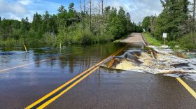
DULUTH — Several areas of Northern Minnesota are under flash flood warnings Tuesday night, June 18, after some communities saw 4 to 6-plus inches of rainfall in a six-hour period and rain continues to fall.
The National Weather Service in Duluth reported the area from Cook to Tower and north, including around Lake Vermilion. As of 6 p.m., the weather service upgraded the flash flood warning for this area to "considerable" flooding, noting several state highways are underwater and street flooding is extensive.
Video courtesy Donna Maxie via "Alerting the citizens of the Iron Range" Facebook group
The Minnesota Department of Transportation reported water over the road on Highway 169 in Hibbing with a detour in effect. The city of Hibbing has already broken its rainfall record for June 18, with heavy rain continuing to fall, according to the weather service. City streets there are reportedly flooded with a least a foot of water reaching up to people's front steps.

Authorities remind the public that they should not attempt to travel in these areas unless they are fleeing from flooding. Do not attempt to cross flooded roads, especially if water is fast-moving. It may be especially dangerous tonight as new areas of flooding may develop as rivers and streams rise.
"Please do not put our first responders lives at risk," the weather service stated.

Severe thunderstorms prompted several weather warnings Tuesday afternoon, including tornado warnings near Ely and between Deer River and Grand Rapids. National Weather Service meteorologist Ketzel Levens in the Duluth office reported seeing a water spout over Lake Superior near Tofte on the Bluefin Bay WaveCam.
Local authorities in the area of Kelsey and Cotton in St. Louis County also reported a possible tornado touchdown in the area.
And on the eastern shores of Leech Lake, hundreds of Lake Country Power customers were without electricity Tuesday afternoon, with tree damage reported in the area. As of 6:45 p.m., nearly 1,000 customers across all of Lake Country Power's territory were experiencing an outage.
Crow Wing Power reported about 100 customers did not have power on Lower Hay Lake on the Whitefish Chain in Crow Wing County. This is almost the exact area hit by a tornado last week.
-
The retiring senator's endorsement in the race between Flanagan and U.S. Rep. Angie Craig comes just before party members share their thoughts on Caucus Night, Feb. 3, 2026.
-
The State Fire Marshal is investigating the cause of the explosion in a six-unit building near the Duluth Airport.
-
Douglas and Tiffany Stewart died Jan. 30, 2026, after a train struck their vehicle west of Cass Lake in rural Hubbard County. The incident is under investigation.
-
U.S. District Court Judge Kate Menendez said the court could not grant a pause of the surge based on the arguments in the case.
-
Plus: Two deans were removed from their positions at Bemidji State University; the Bagley City Council is no longer considering disbanding its police force; and the DNR is seeking 200 summer interns.
-
Plus: Caucus Night is coming on Tuesday — here's what to expect.
-
About 80 students walked three blocks to the Crow Wing County Judicial Center in downtown Brainerd to line both sides of Laurel Street. Many carried anti-ICE signs and chanted together.
-
Michael Hart, 40, previously escaped state custody at the Northeast Regional Corrections facility in St. Louis County in September 2025.
-
Criminal histories include a 2002 DWI conviction for one, and a 2010 underage drinking conviction for the other. Two others arrested without warrants are being held pending removal proceedings.
-
Caucus night is the first step of the political party organizing process, where you can help shape the party platform, support candidates and learn ways to get more involved.


