Play Live Radio
Next Up:
0:00
0:00
0:00 0:00
Available On Air Stations

How bad is it really? The winter severity index with Mark Spoden

Two white-tailed deer stand in deep snow. There is snow on their backs and heads, and the trees behind them are coated in a thick layer. Both deer are looking at the camera. The image is captioned "Winter Severity".
Contibuted
/
Canva
Two white-tailed deer stand in deep snow.

Mark Spoden, Grand Rapids area wildlife manager with the DNR, joined the morning show to discuss how wildlife biologists measure winter severity.

GRAND RAPIDS — The winter of 2023 — well, it’s been a whopper.

Wildlife manager Mark Spoden of the Minnesota Department of Natural Resources said this winter ranks as particularly severe — and this is an objective take, based on the winter severity index. Spoden appeared on the Tuesday, March 28, KAXE Morning Show to explain how the index measures the intensity of seasonal pressures on deer populations with a point system.

Snow depths of 15 inches or greater hinder their movements, and sustained cold temperatures sap their energy reserves. This winter has been particularly severe.

“If your grandpa says, ‘Oh, the snow was a lot deeper when I was a kid, as I walked to school uphill both ways,’ you could say, ‘Well, Grandpa, that might not be true. We’re setting snow depth records now,’” Spoden said.
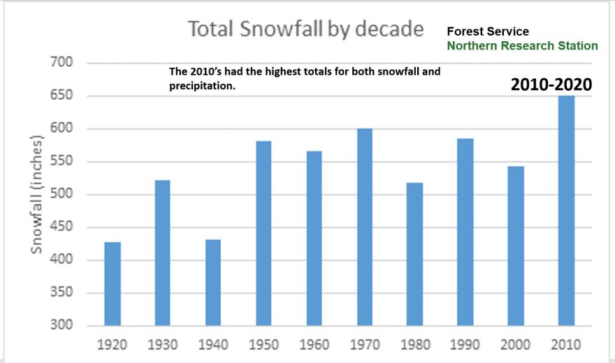
A column graph shows the total snowfall in inches by decade. The graph has an annotation saying "The 2010's had the highest totals for both snowfall and precipitation.". All decades lie between 400-650 inches of snowfall, with the 2010s at the high end (650 inches) and the 1920s and 1940s at the low end (approximately 425 inches).
Contributed
/
Mark Spoden
A column graph shows the total snowfall by decade. The graph has an annotation saying "The 2010's had the highest totals for both snowfall and precipitation.". All decades lie between 400-650 inches of snowfall, with the 2010s at the high end (650 inches) and the 1920s and 1940s at the low end (approximately 425 inches).

How winter severity is measured

A map shows the snow depth across the state of Minnesota for March 23, 2023. It ranges from 0 inches in the Southeastern corner of the state to 48 inches near Duluth. The northern half of the state mostly ranges between 18-24 inches of snow.
Contributed
/
Mark Spoden
A map shows the snow depth across the state of Minnesota for March 23, 2023

The winter severity index is comprised of two major components: temperature and snow depth.

“We start it on November 1 and it runs until May 31,” Spoden explained. “We record one point each day that the temperature is 0 degrees or lower, and then we record one point each day when snow depths are 15 inches or greater.”

These points accumulate throughout the winter. Winters with less than 50 accumulated points are considered mild, while years with 51-119 points are more typical. A year with 120 or more accumulated points is considered severe.

So far, this year’s total is 135 at the Forest Service’s North Central Research station, which qualifies 2023 as a severe winter. Of those 135 accumulated points, 98 come from snow depth and 37 are attributed to temperature. KAXE phenology expert John Latimer’s severity index, which is based on his phenological observations, also suggest this is a particularly severe winter.

Listen to the full KAXE Morning Show segment above!

A map shows the ranking of the snow depth across the state. The ranking runs from 0 at the lowest to 100 at the highest, with colors marking the ranks. The only region ranked under 80 is the Southeastern corner. There is a wide band ranked at 99 two-thirds of the way up the state (through Grand Rapids and Duluth). The far Northern edge is mostly ranked at 80, along with the Twin Cities area.
Contributed
/
Mark Spoden
A map shows the ranking of the snow depth across the state. The ranking runs from 0 at the lowest to 100 at the highest, with colors marking the ranks. The only region ranked under 80 is the Southeastern corner. There is a wide band ranked at 99 two-thirds of the way up the state (through Grand Rapids and Duluth). The far Northern edge is mostly ranked at 80, along with the Twin Cities area.

Effect on deer populations

Due to the difficulty in navigating deep snows, deer congregate in deer yards or snow shelter areas. Spoden has tracked deer traveling up to 30 miles to reach these locations, where large numbers of deer gather to wait out the winter. In mild winters, deer can move about more easily and spread across much larger areas.

Temperatures also play a large role in their survival. Warm days and cold nights cause a thick crust to form on the snow, enabling the deer to access a wider area. A thin crust, however, is dangerous for deer: a wolf may be able to stay on top of a thin crust, while the deer punches through.

Delayed emergence of spring vegetation places considerable strains on pregnant does. If they lose their fawn, however, it comes with a silver lining: without a child to nurse and raise, the doe is able to expend that energy foraging and putting on fat in preparation for the next winter. Spoden’s research indicates these childless does fare considerably better than their counterparts during the subsequent winter.

To learn more, visit:

dnr.state.mn.us/mammals/deer/management/wsi.html

dnr.state.mn.us/mammals/deer/management/statistics.html

dnr.state.mn.us/climate/snowmap/index.html

Stay Connected
Charlie Mitchell (she/they) joined the KAXE team in February of 2022. Charlie creates the Season Watch Newsletter, writes segment summaries for the website, and coordinates our Engaging Minnesotans with Phenology project. With a background in wildlife biology, she enjoys learning a little bit about everything, whether it's plants, mushrooms, aquatic invertebrates, or the short-tailed shrew (did you know they can echolocate?).