


Gusty winds and a wet, heavy snow are expected to impact the Northland beginning at 6 p.m. Tuesday, Feb. 17.
Periods of rain will transition to snow between Tuesday night and Wednesday morning, with heavier snow totals expected north of Highway 2.
Easterly winds up to 30 mph may create blizzard-like conditions along and north of Highway 2.
A National Weather Service spokesperson stated that the area where the rain/snow line converges will determine which area sees the greatest snow accumulation.
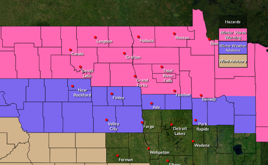


Along the Arrowhead, heavy snow could fall as fast as one inch per hour starting Tuesday night through midday Wednesday, with gusts exceeding 45 mph at times.
Blizzard conditions are expected in the higher terrain of the North Shore beginning at midnight through noon Wednesday.
As the snow is expected to be heavily saturated with moisture, those with medical conditions should take frequent breaks while shoveling to avoid injury.

-
 And: Four Northland organizations recieve child care grants; men encouraged to wear sunscreen and get skin checks; and Eveleth plans to replace the "Big Stick."
 -
 Contributed/Tara Winstead via PexelsResearch shows men are more likely than women to be diagnosed with melanoma, the most dangerous type of skin cancer.
 -
 Co-hosts Charlie Mitchell and Heidi Holtan delight in tiny toads, listen to catbirds, and wonder at crab spiders.Send us a voice memo through Speak Pipe!
 -
 Contributed/InciWebThe U.S. Forest Service is also banning campfires amid dry conditions. The closures and campfire ban go into effect July 11, 2026.


